

Deep Research Epigraphy & Archaeology
20 Historical Discoveries That Reshaped Our Understanding of History
The paradigm shifts that define modern historical understanding are rarely instantaneous. They are the cumulative result of meticulous excavation, interdisciplinary analysis, and the fortunate survival of artifacts through millennia of geologic churn and human conflict.
This report synthesizes the foundational evidence upon which our modern understanding of human antiquity is constructed. By tracing the exact circumstances of their unearthing, the prevailing academic dogmas they dismantled, and their enduring scholarly significance, I wanted to examine twenty of the most consequential historical and archaeological discoveries that have genuinely redefined how we see the past.
Section I — Epigraphy & Documentary Evidence
Decoding the Archives of Ancient Empires

The Behistun Inscription
The historical background of the Behistun Inscription is rooted in the violent succession crisis of the Achaemenid Empire. Around 515 BCE, Darius the Great commissioned a colossal rock relief situated 100 meters up a limestone cliff in western Iran. From my reading of the evidence, the monument was designed to legitimize his ascension to the throne, detailing his victory over the alleged usurper Gaumata and the suppression of rebellions across the provinces.
For centuries, the true nature of the carving was lost to Western scholars. It’s hard to believe now, but in 1598, English diplomat Robert Sherley actually identified the relief as a depiction of Jesus Christ’s ascension—a clear sign of how early explorers forced unfamiliar Eastern monuments into familiar biblical frameworks. The true breakthrough happened in 1835 when Sir Henry Rawlinson recognized its epigraphic value and actually scaled the sheared cliff face to copy the inscriptions.
What Rawlinson discovered was a single proclamation identically etched in three distinct cuneiform scripts: Old Persian, Elamite, and Babylonian (Akkadian). Utilizing earlier foundational work, he successfully deciphered the Old Persian text by 1838. This provided the critical bilingual key necessary to decode the Elamite and Babylonian texts. I tend to think of the Behistun Inscription as the Rosetta Stone of Mesopotamia; it essentially birthed modern Assyriology and allowed us to read millennia of Near Eastern history.
How We Decode Ancient Scripts Today
The Ebla Tablets
Prior to the mid-20th century, the academic consensus surrounding the Bronze Age Near East posited a bipolar world dominated by the riverine civilizations of Egypt and Mesopotamia, effectively reducing the Levant to a culturally derivative periphery. The discovery of ancient Ebla completely reshaped that map.
Between 1974 and 1975, an Italian expedition led by Paolo Matthiae excavated Tell Mardikh in northern Syria. Inside the ruins of Royal Palace G, the team uncovered an archive yielding roughly 1,800 intact cuneiform tablets and thousands of cataloged fragments. While early press releases made bold claims that these tablets directly confirmed the historical accuracy of the biblical patriarchs, modern Semitic philology has largely dismissed those connections.
Instead, my reading of the evidence is that their real value lies in the documentation of an expansive, highly advanced commercial empire. The texts were written in a local Semitic language, Eblaite, and detailed trade networks stretching from the Mediterranean coast to Anatolia. They proved that urbanization and complex statecraft in the Levant were indigenous and fully contemporary with the Akkadian Empire.
Trade & Commerce in Ancient Civilizations
Sanxingdui Sacrificial Pits
For decades, Sinology was dominated by the “Yellow River hypothesis,” which argued that Chinese civilization originated solely in the Central Plains and diffused outward. The discoveries at Sanxingdui in the Sichuan Basin challenged this unilinear narrative, providing strong evidence for a more pluralistic model of early Chinese civilizational origins.
While local brickyard workers stumbled upon the first caches of jade and bronze in 1986, it was the systematic excavation of new sacrificial pits between 2020 and 2022 that brought the site’s true scale into focus. The artifacts defy established Central Plains typologies: archaeologists recovered colossal bronze masks with exaggerated eyes, a massive bronze tree, and life-sized human statues. The artifacts were intentionally broken, burned at high temperatures, and meticulously layered with ash and elephant tusks.
Radiocarbon dating places this massive sacrificial event around 1050 BCE. Interestingly, recent metallurgical analysis also revealed a meteoritic iron axe, suggesting sophisticated cross-regional trade. From what the excavation reports show, the absence of human remains and the ordered deposition indicate conscious ritual decommissioning rather than wartime destruction. It’s clear to me that the ancient State of Shu possessed an autonomous religious and artistic tradition of staggering complexity.
Lost Civilizations That Were Far More Advanced Than Believed
The Rosetta Stone
The translation of the Rosetta Stone undeniably marks the genesis of modern Egyptology. Discovered in 1799 by French engineering officer Pierre-François Bouchard during Napoleon Bonaparte’s expedition in Egypt, the fractured granodiorite stele was unearthed while reinforcing Fort Julien near the town of Rashid (Rosetta). Following the French capitulation, the artifact was transferred to the British Museum in 1802.
The stele records a priestly decree issued in Memphis in 196 BCE, affirming the royal cult of King Ptolemy V Epiphanes. Its immense scholarly value lies in its tripartite inscription. The identical text is carved in Ancient Egyptian hieroglyphs, Demotic, and Ancient Greek.
Because the Ancient Greek language was well-documented among European academics, the text provided a direct bilingual translation matrix. While the story is often told as a solo triumph, it’s important to remember that the decipherment relied on foundational work by English polymath Thomas Young alongside the decisive phonetic breakthroughs by Jean-François Champollion in 1822. This combined effort unlocked three millennia of Pharaonic history, finally giving voice to ancient Egyptian monuments.
History’s Most Expensive Objects
The Antikythera Mechanism
In the spring of 1901, Greek sponge divers sheltering from a storm off the small island of Antikythera discovered a massive Roman-era shipwreck. Among the recovered cargo of marble statues and amphorae was a heavily encrusted, corroded lump of bronze and wood. Initially overlooked, the artifact later split apart in storage, revealing precision-cut gear teeth.
Dating to approximately 200–60 BCE, I’d argue the Antikythera Mechanism is best described as an exceptionally sophisticated ancient mechanical astronomical calculator. While it’s widely popularized in the media as the world’s first “analogue computer,” we have to be careful not to project modern electronic architecture onto ancient engineering. Decades of investigation, culminating in high-resolution microfocus X-ray computed tomography (CT), revealed a staggeringly complex internal architecture comprising at least 30 surviving bronze gear wheels.
Operated by a hand crank, the device calculated astronomical positions, the phases of the moon, and predicted eclipses based on the Babylonian Saros cycle. The engineering precision required to design epicyclic gearing of this caliber was previously thought to have been invented during the European Renaissance. The mechanism heavily implies a lost Hellenistic tradition of advanced engineering that disappeared during the collapse of the classical world.
The Evolution of Standardized Time
Göbekli Tepe
For much of the 20th century, the established paradigm of human development dictated that the domestication of plants and animals was the necessary prerequisite for settled communities, which in turn generated the surplus labor required for monumental architecture. Göbekli Tepe, located in southeastern Turkey, structurally inverted this sequence.
Dismissed in a 1963 survey as a medieval cemetery, the site’s true significance was recognized in 1994 by Klaus Schmidt of the German Archaeological Institute. Radiocarbon dating placed the construction of its massive circular enclosures around 9600–8000 BCE. The site features monolithic T-shaped limestone pillars, some weighing up to 10 tons, intricately carved with low-relief images of foxes, scorpions, vultures, and lions. It is undoubtedly one of the earliest known monumental megalithic sites on Earth.
Initially, Schmidt hypothesized that Göbekli Tepe was a purely ritual center—a “temple”—built by mobile hunter-gatherers, suggesting that the urge to worship sparked civilization. However, I wouldn’t call the debate settled. Recent excavations have identified nearby domestic structures, and interpreting it purely as a non-residential temple is actively contested. Still, it remains a critical site that challenges our traditional timelines regarding complex architecture and hunter-gatherer social organization.
Humanity’s Near-Extinction Event“Archaeology is the search for fact, not truth. But when the facts rewrite thousands of years of established orthodoxy, they become the closest thing to historical truth we have.”
The Historical Insights Research Notes
The Dead Sea Scrolls
The discovery of the Dead Sea Scrolls is widely regarded as one of the greatest manuscript finds of the 20th century. In the winter of 1946–1947, a young Bedouin shepherd named Muhammad edh-Dhib was searching for a stray goat among the limestone cliffs of the Judean Desert near the Dead Sea. Tossing a stone into a narrow cave opening, he heard shattering pottery. Upon entering, he found tall clay jars containing ancient parchment and papyrus scrolls wrapped in linen.
Over the ensuing decade, excavators recovered roughly 25,000 fragments representing over 900 distinct manuscripts from eleven caves near Qumran. Dating from the 3rd century BCE to the 1st century CE, the texts are written primarily in Hebrew, with some Aramaic and Greek. They contain the oldest known surviving copies of the Hebrew Bible, predating previously accepted texts by a full millennium.
While the scrolls are often associated with an ascetic Jewish sect known as the Essenes, I’d point out that their exact authorship and origins remain debated among scholars. Some researchers argue the texts represent manuscripts gathered from multiple libraries in Jerusalem and hidden during the Roman siege. Regardless, the scrolls illuminate a period of intense religious diversity, providing a critical textual bridge to understanding the historical milieu from which both rabbinic Judaism and early Christianity emerged.
Cursed and Sacred Objects in History
The Terracotta Army
In March 1974, a group of farmers sinking a well during a drought in Lintong County, outside Xi’an, China, struck fragments of fired clay. They had unwittingly breached the outer defenses of the most extensive imperial necropolis ever constructed: the mausoleum of Qin Shi Huang, the first Emperor to unify China, who died around 210 BCE.
Subsequent excavations revealed a subterranean military garrison of staggering proportions. Spread across three massive timber-lined pits are an estimated 8,000 life-sized terracotta soldiers, chariots, and cavalry horses. The figures were mass-produced in workshops using standardized modular clay parts, yet artisans individually hand-finished each face to ensure no two warriors looked identical.
Perhaps the most famous story regarding the army is the condition of the real bronze weapons found clutched by the statues. For decades, early hypotheses suggested that Qin armorers applied an advanced chromium-based anti-rust treatment, seemingly inventing chromate conversion coating two millennia early. However, a rigorous 2019 study published in Scientific Reports completely refuted this. The chromium traces were actually just unintended contamination from nearby decorative lacquer varnishes on the handles. Based on the latest data, the exceptional preservation of the bronze weapons is simply attributed to the high tin content of the alloy and the protective alkaline pH of the local Xi’an soil. Sometimes the truth is less about ancient high-tech and more about fortunate soil chemistry.
Lost Treasures Worth Billions
The Ruins of Pompeii
In 79 CE, Mount Vesuvius erupted, burying the thriving Roman city of Pompeii under meters of volcanic ash and pumice. The rapid, oxygen-deprived burial acted as a macroscopic time capsule. While it’s often described as a single, pristine instant frozen in time, there’s actually plenty of archaeological evidence indicating multi-phased destruction and post-eruption looting in antiquity. Still, the site lay largely undisturbed until systematic excavations began in 1748 under the Bourbons.
The excavation of Pompeii fundamentally transformed classical archaeology. Prior to this, historians relied on idealized classical texts and the monumental marble ruins of Rome. Pompeii, conversely, was a provincial commercial hub that offered an unfiltered, granular view of ancient urban sociology. Excavators uncovered political graffiti, fast-food counters, complex water distribution networks, and loaves of bread perfectly carbonized in bakery ovens.
The most visceral aspect of the discovery, of course, was the human toll. In the 1860s, archaeologist Giuseppe Fiorelli realized that voids in the compacted ash were the exact negative impressions of victims’ bodies. By pouring liquid plaster into these cavities, he preserved the final postures of Pompeii’s citizens. From my perspective, the site provides unparalleled demographic and dietary data, serving as the absolute bedrock for modern studies of Roman daily life.
Roman Concrete: Ancient Architectural Durability
The Vindolanda Tablets
The periphery of the Roman Empire was long considered a desolate, illiterate frontier. This assumption was systematically dismantled in March 1973 during excavations at Vindolanda, a Roman auxiliary fort situated just south of Hadrian’s Wall in northern England. Archaeologist Robin Birley and student Keith Liddell were examining a waterlogged, oxygen-free layer of soil when they recovered what appeared to be wood shavings. When peeled apart, these slivers of birch and oak revealed cursive Latin script written in carbon-based ink.
Dating primarily to the late 1st and early 2nd centuries CE, these postcard-sized leaf-tablets constituted the administrative and personal archives of the fort’s inhabitants. The texts cover logistics, intelligence reports, requests for beer, and personal correspondence.
The most celebrated artifact is Tablet 291, a birthday invitation written around 100 CE from Claudia Severa to her friend Sulpicia Lepidina. While the majority of the letter was dictated to a scribe, Severa added an affectionate closing greeting in her own handwriting. It’s an incredible artifact that brings ancient people to life—making it one of the earliest known surviving examples of a document written in Latin by a woman. The tablets proved that literacy was common across genders and ranks, even at the furthest edge of the empire.
Why Addresses Have Numbers: The History of Urban Logistics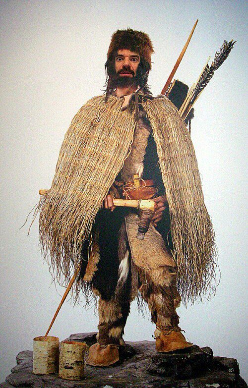
Ötzi the Iceman
In September 1991, two German tourists trekking through the Ötztal Alps discovered a human torso emerging from a melting glacier. Initially assuming the body belonged to a recently deceased mountaineer, authorities extracted the remains. After an archaeological inspection of his accompanying gear, radiocarbon dating placed the man’s death around 3350–3105 BCE, during the European Copper Age.
Ötzi is Europe’s oldest known natural human mummy. The sub-zero glacial environment acted as a prehistoric freezer, preserving his skin, internal organs, and the contents of his gastrointestinal tract. He carried a highly advanced, 99.7% pure copper axe, which forced historians to push back the timeline of copper smelting in Alpine Europe. Pathological analysis also revealed a violent end: an arrowhead lodged in his left shoulder severed his subclavian artery.
I tend to think his discovery is one of the most unparalleled bioarchaeological finds we have. Interestingly, a 2023 genomic re-analysis by the Max Planck Institute really refined our picture of him, updating older genetic profiles to reveal a strong Anatolian farmer lineage, much darker skin pigmentation than previously thought, and even male pattern baldness.

Lascaux Cave
On September 12, 1940, eighteen-year-old Marcel Ravidat was exploring the woods near Montignac in the Dordogne region of southwestern France. After his dog discovered a deep hole, Ravidat returned with friends to widen the entrance. They entered a vast subterranean complex adorned with some of the most extraordinary parietal art ever discovered, dating back approximately 17,000 to 15,000 years to the Upper Paleolithic period.
Lascaux contains nearly 2,000 figures, predominantly depicting local megafauna: equines, stags, aurochs, and felines. The sheer scale and artistic mastery of the paintings—particularly in the Hall of the Bulls—fundamentally shifted how scholars viewed the cognitive capabilities of early humans. The artists utilized the natural undulating contours of the cave walls to impart three-dimensional volume to the animals, employing blown mineral pigments.
While discovering the art was a triumph, conserving it has been an ongoing challenge. It’s important to note that you can’t actually walk into the original cave today. It was permanently closed to the public in 1963 because the carbon dioxide and moisture from human breath were creating microclimates that fueled destructive fungal growth. Today, visitors access the meticulous Lascaux II and IV replicas to experience the art safely.

Chauvet Cave
The discovery of the Chauvet-Pont-d’Arc Cave fundamentally reorganized the chronology of human artistic development. On December 18, 1994, speleologists detected a draft emanating from a scree slope in the Ardèche gorge. Clearing the debris, they penetrated a vast cavern sealed by a cliff collapse roughly 29,000 years ago.
Inside, they found hundreds of breathtakingly realistic black charcoal paintings predominantly depicting apex predators: cave lions, panthers, woolly rhinoceroses, and bears. When radiocarbon dates placed the artwork in the Aurignacian period—approximately 32,000 to 36,000 years ago—they ignited intense scholarly debate. Many traditional models simply couldn’t accept such high levels of artistic mastery that early on.
These dates shattered the old evolutionary theory of art, which assumed a slow, linear progression from simple scribbles to complex representation. The artists here used highly advanced techniques: stump-drawing to create 3D shading, scraping the rock to create a bright canvas, and drawing superimposed legs to convey dynamic movement. It seems pretty clear that anatomically modern humans arrived in Europe with their cognitive and artistic capacities already fully formed.

The Uluburun Shipwreck
In the summer of 1982, a local Turkish sponge diver reported seeing “metal biscuits with ears” resting on a steep slope 50 meters below the surface off the Mediterranean coast. This observation initiated one of the most important marine archaeological endeavors in history. Between 1984 and 1994, the Institute of Nautical Archaeology conducted over 22,400 dives to excavate what remains one of the wealthiest shipwrecks ever discovered.
Those “biscuits” turned out to be 350 Cypriot copper oxhide ingots which, along with 1 ton of tin, provided the exact ratio required to smelt bronze. Dendrochronological dating of the cedar hull placed the ship’s sinking around 1320–1300 BCE.
The cargo provides incredible evidence for extensive long-distance exchange networks across the Late Bronze Age eastern Mediterranean. It contained elite goods from at least seven distinct cultures (Mycenaean, Syro-Palestinian, Cypriot, Egyptian, Kassite, Assyrian, and Nubian). Finding Baltic amber, Canaanite jars, and a unique solid gold scarab of the Egyptian Queen Nefertiti in one place physically proves that the Late Bronze Age Mediterranean was bound by a highly complex web of commerce and royal gift-exchange.
Roman Harbor Engineering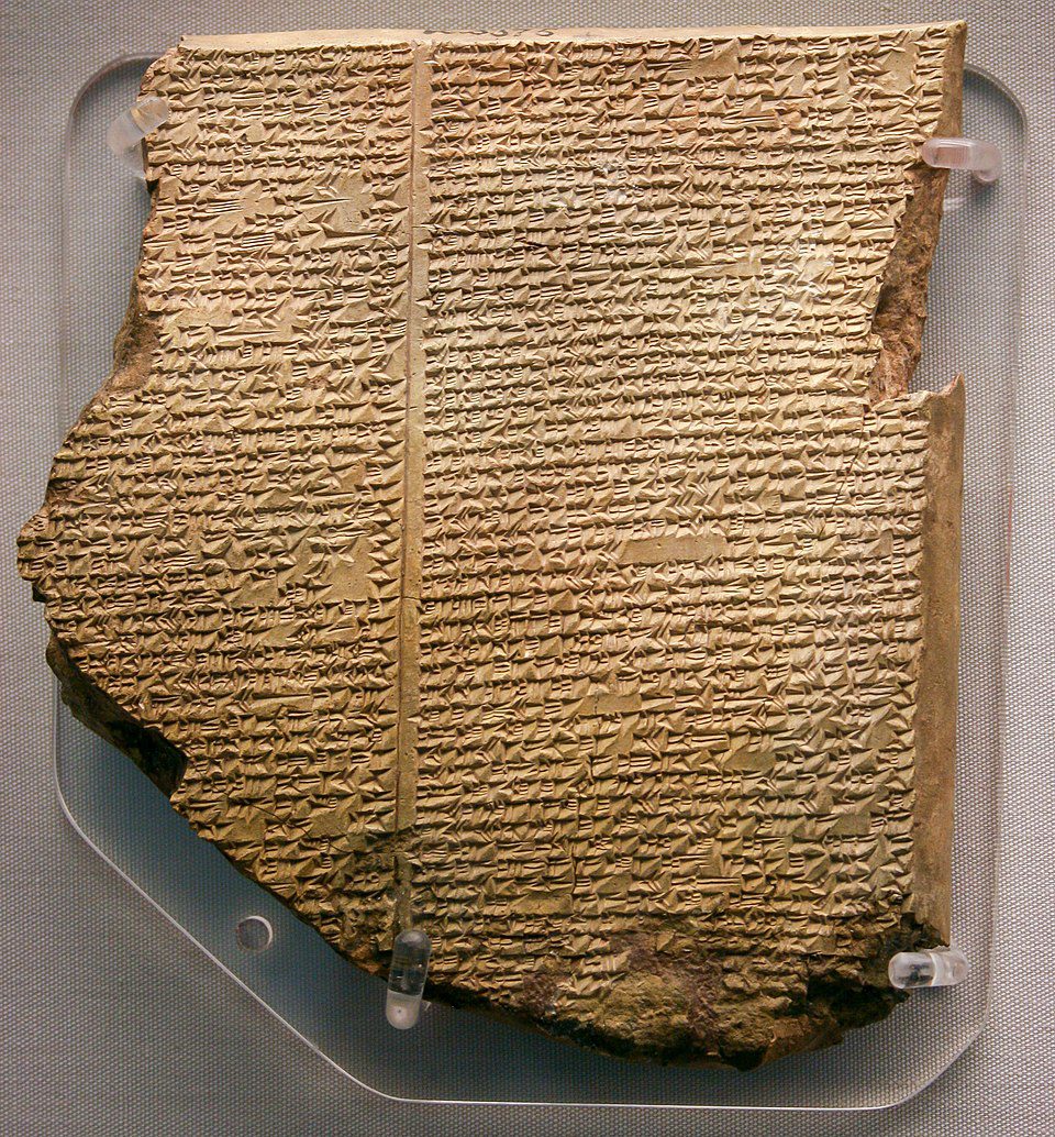
The Library of Ashurbanipal
In the mid-19th century, European interest in biblical archaeology drove extensive excavations across Mesopotamia. In 1849, British archaeologist Austen Henry Layard discovered thousands of clay tablets in the ruined palace of Sennacherib at Nineveh. Four years later, his associate Hormuzd Rassam uncovered an even larger archive. Together, these finds constituted the Library of Ashurbanipal, arguably the world’s first systematically collected and cataloged universal library, containing approximately 30,000 cuneiform tablets and fragments.
Ashurbanipal was a rare ancient monarch who was fully literate and prided himself on his ability to read complex Sumerian and Akkadian texts. The library was a massive repository of Mesopotamian science, medicine, divination, and literature. The scholarly impact hit critical mass in 1872 when George Smith translated a fragment known as the “Flood Tablet”.
This tablet contained a segment of the Epic of Gilgamesh detailing how a god warned a hero of an impending global deluge, instructing him to build a boat to save terrestrial life. The narrative closely mirrored the biblical story of Noah’s Ark, yet it had been recorded centuries earlier. This revelation shook Victorian society, forcing historians to acknowledge that many foundational biblical traditions had deep roots in older Near Eastern literature.

The Herculaneum Papyri
During the catastrophic 79 CE eruption of Mount Vesuvius, a luxurious seaside villa in Herculaneum was engulfed by a pyroclastic surge reaching 500°C. The intense heat instantly flash-carbonized the villa’s extensive library, turning hundreds of papyrus scrolls into brittle lumps of charcoal. First discovered in 1752, early attempts to physically unroll the texts resulted in tragic destruction, causing the scrolls to flake into dust.
For centuries, the intact scrolls were deemed unreadable because ancient scribes utilized carbon-based ink, which was chemically indistinguishable from the carbonized papyrus under traditional X-rays. This barrier was finally broken in 2023 through the “Vesuvius Challenge.” Rather than AI just magically “unlocking” the scrolls on its own, researchers utilized high-resolution 3D micro-CT scans combined with machine learning algorithms trained to detect microscopic textural variations caused by the ink.
A global team successfully deciphered columns of text containing over 2,000 characters. The unwrapped text, authored by the Epicurean philosopher Philodemus, discusses the nuances of pleasure derived from music and food. This breakthrough technology provides us with our best shot at reading the only intact library surviving from classical antiquity.

L’Anse aux Meadows
For generations, the Icelandic Sagas described Norse voyages to a land west of Greenland called Vinland, established around 1000 CE. Without physical evidence, many scholars relegated these sagas to folklore. That changed in 1960 when Norwegian explorer Helge Ingstad and archaeologist Anne Stine Ingstad surveyed Epaves Bay at the northern tip of Newfoundland, Canada.
Excavations revealed the undeniable foundations of timber-and-turf longhouses, architecturally identical to those utilized in Viking Age Iceland and Greenland. Crucially, the team uncovered unambiguous Norse artifacts, including a bronze ring-headed cloak pin, a bone spindle whorl, and a bog iron smelting forge containing iron slag.
While the site was long estimated to date around the turn of the millennium, a brilliant 2021 study in Nature provided incredible precision. Researchers utilized a known cosmic ray spike (the Miyake event) embedded in the tree rings to pinpoint the exact year the timber was felled: 1021 CE. From what the site layout and stratigraphy show, I tend to think it was a short-lived seasonal base camp and repair station rather than a permanent colony. Still, it remains the first and only widely accepted evidence of pre-Columbian trans-oceanic contact.

Australopithecus afarensis (Lucy)
In the mid-20th century, paleoanthropology was locked in a fierce debate regarding the sequence of human evolution: did early hominins evolve large brains first, which allowed them to walk upright, or did bipedalism precede brain growth? The discovery of AL 288-1 in November 1974 decisively settled the argument.
While surveying the arid ravines of Hadar in the Afar Triangle of Ethiopia, paleoanthropologist Donald Johanson spotted a forearm bone protruding from the sediment. Over several weeks of meticulous screening, Johanson and his team recovered 47 bones, representing roughly 40% of a single hominin skeleton by weight. The specimen was affectionately named “Lucy,” inspired by the Beatles song playing in the expedition camp.
Dating to roughly 3.2 million years ago, Lucy belonged to the species Australopithecus afarensis. Her morphology provided a striking evolutionary mosaic. Her pelvis, femur, and knee joint clearly demonstrated that she walked fully upright (bipedalism), yet her cranial capacity was only about 400 cubic centimeters, roughly the size of a modern chimpanzee. Lucy proved conclusively that the evolutionary split separating the human lineage from other great apes was catalyzed by bipedalism, not a sudden expansion in brain size.

The Denisovans
Historically, the identification and taxonomy of hominin species were dictated purely by morphological analysis—the physical shapes of recovered skulls and bones. The Denisovans broke this fundamental rule, becoming the first human ancestor identified almost exclusively through ancient DNA analysis rather than full skeletal reconstructions.
In 2008, Russian archaeologists excavating the dirt floor of Denisova Cave in the Altai Mountains uncovered a tiny, unremarkable pinky bone from a juvenile female. By 2010, researchers successfully extracted and sequenced mitochondrial DNA from the fragment. The genomic data was revolutionary. The DNA didn’t match modern Homo sapiens, nor did it match our closest known relatives, the Neanderthals. It belonged to an entirely new, deeply divergent sister lineage.
Further sequencing revealed a deeply complex Pleistocene landscape where Denisovans inhabited vast stretches of Asia and successfully interbred with other hominins. In 2018, researchers discovered “Denny” in the same cave—a first-generation hybrid with a Neanderthal mother and a Denisovan father. Today, genetic introgressions from this vanished species survive in the genomes of modern Melanesians and Tibetans. To me, the Denisovan discovery firmly proves that human evolution was not a simple linear tree, but a highly braided stream of populations.

The Code of Hammurabi
Between 1901 and 1902, the French Délégation en Perse was excavating the ancient Elamite capital of Susa in modern-day Iran. Beneath the ruins, they unearthed a towering, 2.25-meter basalt stele that had been broken into three massive pieces. Translators quickly decoded the dense Akkadian cuneiform etched across its surface, revealing it to be an incredibly comprehensive legal text.
Enacted by the Babylonian King Hammurabi around 1750 BCE, the stele features 282 specific edicts governing everything from maritime trade and marriage contracts to medical malpractice and slave liability. It famously formalized the principle of lex talionis—the law of exact retribution, or “an eye for an eye.” More profoundly, it introduced fundamental concepts that anchor modern justice systems, like requiring accusers to bring forth evidence or face perjury charges themselves.
While it is frequently popularized as the “world’s oldest legal code,” my reading of the evidence aligns with most modern specialists: older Sumerian collections, like the Code of Ur-Nammu, definitely predate it. Today, historians classify Hammurabi’s text more as a monumental compilation of royal jurisprudence and case law rather than a modern statutory code. Nonetheless, it remains the most influential legal monolith ever recovered.
Ancient Measurement Systems Before Written LawThe Economics and Philosophy of the Irreplaceable
The artifacts and discoveries detailed in this report share a common characteristic that defies traditional archaeological valuation: the absolute impossibility of substitution. A society can forge new alloys, construct new architecture, and codify new laws. However, it cannot recreate the exact atmospheric and chemical conditions that carbonized an Epicurean library, nor can it forge a 32,000-year-old charcoal lion onto a limestone wall.
What these discoveries collectively demonstrate is that the human narrative is not a steady, unbroken, unilinear climb from primitive ignorance to modern sophistication. It is a highly fragile lineage characterized by lost technologies, forgotten languages, shifting climates, and interbreeding species. The Antikythera Mechanism proves that mechanical genius can be achieved and subsequently lost for over a thousand years. The Chauvet Cave illustrates that the capacity for breathtaking artistic abstraction has existed in our species essentially from the moment anatomically modern humans migrated into Europe. The genomic ghost of the Denisovans shows us that we were never alone on this planet.
Ultimately, these artifacts serve as temporal mirrors. When researchers dedicate decades of effort, vast capital, and advanced computational resources to read a carbonized scroll or extract DNA from a pulverized bone fragment, they are making a profound statement about civilization’s relationship with loss. The deepest truth of modern archaeology is that the impulses driving the ancient world—the desire for legal justice, the need to map the stars, the compulsion to write down the poetry of our existence, and the deep, abiding need to be remembered—are precisely the same impulses that drive us to unearth them today. By synthesizing epigraphy, genomics, and digital reconstruction, these discoveries do not merely append new facts to the timeline—they fundamentally transform the methodology by which we reconstruct the human narrative.
References & Archival Sources
- British Museum Archives: The Rosetta Stone Collection Data; Library of Ashurbanipal Translation Ledgers; Vindolanda Tablets Digital Index.
- Musée du Louvre, Paris: Code of Hammurabi Stele Inventaire E 11258; Elamite Antiquities Collection.
- National Archaeological Museum, Athens: Antikythera Mechanism Research Project (AMRP) Reports.
- Smithsonian Institution: The Mystery of the World’s Oldest Writing System Remained Unsolved Until Four Competitive Scholars Raced to Decipher It (Smithsonian Magazine).
- UNESCO World Heritage Centre: Site inscriptions for Behistun (2006), Göbekli Tepe (2018), Chauvet Cave (2014), L’Anse aux Meadows (1978).
- Academic Journals: Cambridge Archaeological Journal (Neolithic Cultural Heritage); DOI (Earliest meteoritic iron artefact of the Chinese Bronze Age discovered at Sanxingdui).
- University Publications: UK Research (‘Grand Prize’ discovery made from 2,000-year-old Herculaneum scrolls); ETH Zurich (Breakthrough in the study of ancient scrolls); BYU Religious Studies Center (The Ebla Tablets).
- Vesuvius Challenge: 2023 Grand Prize Award Records and Digital Decipherment Whitepapers (Scrollprize.org).
- Institute of Nautical Archaeology: Uluburun Late Bronze Age Shipwreck Excavation Reports (George F. Bass & Cemal Pulak).
- World History Encyclopedia: Behistun Inscription, Chauvet Cave, Code of Hammurabi.
Expert Inquiry
Frequently Asked Questions
Authoritative answers to key questions concerning excavation methodology, epigraphic decoding, and historical significance.
How did the Behistun Inscription help decipher cuneiform?
Commissioned by Darius I, the Behistun Inscription contained the exact same proclamation in three distinct cuneiform scripts: Old Persian, Elamite, and Babylonian. Scholars deciphered the Old Persian text first by matching royal names to Greek texts. Once Old Persian was understood, they used it as a bilingual key to decode the vastly more complex Babylonian text, permanently unlocking the written records of ancient Mesopotamia.
Why is Göbekli Tepe considered so important to human history?
Göbekli Tepe upended the established archaeological consensus that complex, monumental architecture was only possible after a society developed agriculture. Dating back to roughly 9600 BCE (Pre-Pottery Neolithic), it was built by hunter-gatherers thousands of years before the advent of farming, metal tools, or the wheel.
How did artificial intelligence read the Herculaneum Papyri?
The Herculaneum Papyri were carbonized into fragile lumps of ash by the eruption of Mount Vesuvius in 79 CE. In 2023, the Vesuvius Challenge utilized high-resolution 3D CT scans. Contestants trained machine-learning algorithms to detect microscopic variations in the papyrus texture caused by ancient carbon-based ink, allowing the text to be virtually unwrapped.
What did the Uluburun Shipwreck reveal about the Bronze Age?
Sinking around 1320 BCE, the Uluburun Shipwreck provided incredible evidence of a highly sophisticated maritime trade network in the Late Bronze Age. Its cargo included raw materials and luxury goods from at least seven different cultures across the Mediterranean and Near East, including Cypriot copper, Baltic amber, and an Egyptian scarab of Nefertiti.
Why are the dates of the Chauvet Cave paintings controversial?
When Chauvet Cave was discovered in 1994, radiocarbon dating placed the majority of its artwork in the Aurignacian period, 32,000 to 36,000 years ago. Some traditional archaeologists initially argued that the highly realistic shading and perspective techniques were too advanced for this era. However, comprehensive geomorphological analysis of the rockslide that sealed the cave, alongside hundreds of new radiocarbon dates, confirmed the extreme antiquity of the art.

[…] reading on The Historical Insights: archaeological and historical discoveries, how radiocarbon dating and modern science are rewriting history, and how institutions have used […]