Archaeology & Infrastructure
What Ancient Roads Reveal About Civilization Before Borders
How ancient paths, trade routes, and imperial highways reveal the changing relationship between movement, commerce, political power, and territorial control.


In the late 1960s, analysts working through declassified CORONA spy satellite photographs of northern Syria noticed something that had nothing to do with the Cold War. Radiating outward from ancient settlement mounds like Tell Brak were broad, shallow depressions, some stretching five kilometers into the surrounding steppe. Landscape archaeologists later confirmed what the images suggested: these were hollow ways, sunken channels worn into the earth over centuries by the feet of farmers, the hooves of pack donkeys, and the passage of sheep and goat herds moving between city and field. No king ordered them built. No surveyor laid them out. They simply accumulated, the way a footpath across a park lawn accumulates, until the land itself recorded the traffic.
That image is a useful place to start, because it complicates a story that is often told too simply: that roads came first and empires followed, or the reverse. The archaeological record shows something less tidy and more interesting. Human movement carved the earliest arteries of connection long before any state existed to claim them. But once states and empires did develop, they rarely left those arteries alone. They surveyed them, paved them, taxed them, garrisoned them, and in some cases restricted who could use them at all. Ancient roads, in other words, reveal a civilization that existed before modern political borders, but not one that existed without power, taxation, or control of its own.
Before Roads: How Movement Created Routes
The most basic transport feature in the archaeological record is not a road at all. It is a path: an unengineered line of foot traffic that follows the contours of a landscape, tracing ridgelines, riverbanks, and the shortest walkable line between two points. Anthropologists studying movement describe this as a mechanical process rather than a designed one. Repeated footsteps compress soil, kill vegetation, and channel rainfall runoff along the same narrow line, and over generations that line deepens into a sunken lane, or hollow way. This is worth naming precisely, because a popular but inaccurate label has attached itself to the phenomenon. “Desire path” is a twentieth-century term from urban planning and landscape design, coined to describe pedestrians cutting corners across a modern lawn. Applying it to Bronze Age Mesopotamia or Neolithic Europe collapses two very different phenomena into one, and archaeologists working on ancient transit corridors use “hollow way” or “sunken lane” instead.
It’s also worth being precise about what these early exchange networks actually moved. Epipaleolithic Natufian communities in the Levant, active around 12,500 to 9,500 BCE, are sometimes credited with trading grain across hundreds of miles. The archaeological evidence does not support that claim. What Natufian sites do show is the down-the-line exchange of marine shells and small quantities of Anatolian obsidian, passed from group to group without any centralized organization or fixed route. Grain, by contrast, was harvested locally and was far too heavy to move any meaningful distance on foot. The distinction matters, because it shows that decentralized, kinship-based exchange networks were real and often stretched impressively far, without needing to inflate what specific goods moved across them.
The First Engineered Trackways
Somewhere between an unplanned footpath and a modern highway sits a category of infrastructure that is genuinely engineered but not the product of any state: the communal causeway. The clearest surviving example is the Sweet Track, built across the Somerset Levels in southwest England to connect the sand island of Westhay to the Polden Hills. Dendrochronological analysis of its surviving oak and ash timbers dates its construction with unusual precision to the winter of 3807 or 3806 BCE. Farmers felled oaks up to 400 years old, split the trunks into long planks using wooden wedges and stone axes, and pegged them end-to-end atop a submerged rail, moving an estimated 200,000 kilograms of timber across a flooded reed swamp. Pollen analysis suggests the whole two-kilometer structure was completed within a single season, coordinated by a farming community that had no king, no bureaucracy, and no writing system to record the effort. The track was abandoned after roughly a decade as water levels rose, and in 2009 archaeologists working near Belmarsh in London excavated an even older timber trackway, dated to around 4100 BCE, confirming that wetland engineering of this kind was an established Neolithic practice across Britain rather than a one-off achievement.

State-level engineering, when it does appear this early, was not built to connect cities at all. The oldest surviving stone-paved road anywhere in the world is the Widan el-Faras quarry road in Egypt’s Faiyum Depression, dated by associated pottery and tools to the 4th and 5th Dynasties of the Old Kingdom, roughly 2600 to 2200 BCE. It runs 11.5 kilometers from basalt quarries at Gebel Qatrani to the ancient shoreline of Lake Moeris, a consistent 2.1 meters wide, paved with unworked slabs of basalt, sandstone, and petrified wood laid directly over the desert. Workers hauled quarried basalt on wooden sledges down this surface to the lake, where the stone was loaded onto barges and floated up the Nile to pave temple floors at Giza and Abusir. It is, in a sense, the earliest evidence of a state building a road for a specific extractive purpose rather than for general travel.
Water Before Stone: Why Early Civilizations Relied on Rivers and Coasts
It is tempting to say civilization began with roads. The archaeological record says otherwise. Urbanism, sedentism, and the earliest states formed along the alluvial floodplains of the Tigris, Euphrates, Nile, and Indus, and along stretches of navigable coastline, millennia before any engineered regional road network existed. Water did the work that roads would later be credited with. A single wooden or bitumen-coated reed barge moving downstream could carry perhaps twenty tons of grain, timber, or mudbrick with minimal labor. An overland donkey pack train, by comparison, carried around 80 kilograms per animal and required daily feeding, which meant that overland bulk transport became prohibitively expensive within a few dozen miles. In southern Mesopotamia specifically, there was also no local stone or timber to pave a road with even if one had been wanted; cities grew instead along braided river channels and artificial canals that served as irrigation and transport infrastructure at once.
This has a direct bearing on one of the more persistent myths about ancient roads: that they routinely moved bulk grain to relieve famine. They did not, and could not, at any meaningful scale. A wagon of grain pulled by oxen or mules loses value to its own draft animals’ fodder consumption at a rate that roughly doubles the effective cost of the cargo every 50 to 75 miles. Bulk famine relief depended on river and sea transport, or on localized storage, such as the Inca state granaries known as qollqas. Overland roads, where they existed, carried high-value goods, seed stock, messages, and soldiers, not sacks of wheat destined to feed a starving province three hundred miles away.
Trade Networks Before Large Empires
Long-distance exchange in the ancient world is often described as evidence of a more open, borderless past. The evidence points somewhere more specific. Trade moved along a spectrum, from informal reciprocal gift exchange with no fixed route at all, up through chartered merchant colonies operating under royal treaty, to fully state-maintained relay corridors with checkpoints and passports. None of these stages was free of friction. Along the Eurasian steppe bronze networks of roughly 2200 to 1500 BCE, copper, tin, and finished weapons moved thousands of kilometers through nomadic confederations organized around warrior aristocracies and reciprocal gift exchange rather than states. On the Arabian incense route, camel caravans carrying frankincense and myrrh from southern Arabian kingdoms to Gaza and Alexandria paid fixed tithes to priests, guards, and gatekeepers at every station along the way; Pliny the Elder recorded that these cumulative levies inflated the final Roman price of aromatics by more than a hundredfold. Later, on the trans-Saharan gold and salt routes, caravans depended on Berber and Tuareg guides to find water in the desert, and failing to negotiate an escort could mean an ambushed caravan or a blocked well. None of this looks like frictionless cooperation. It looks like commerce conducted through constant, deliberate risk management.
Old Assyrian Merchants and the Roads to Kültepe
The clearest documentary window onto how this actually worked comes from central Anatolia, where more than 23,000 cuneiform tablets have been excavated at the lower merchant city of Kültepe, ancient Kaneš. Between roughly 1950 and 1750 BCE, merchants from the city of Aššur organized donkey caravans carrying tin and Babylonian wool textiles more than a thousand kilometers across the Taurus Mountains into Anatolia, where the goods were sold for silver and gold that was sent back home. A common but inaccurate description of this trade imagines merchants relying on roadside inns, something like a Bronze Age caravanserai. The tablets describe a more formal arrangement. Assyrian traders operated out of chartered settlements called kārum, literally “quay” or “harbor,” which functioned as full administrative colonies with their own judicial assemblies and financial archives, and smaller branch outposts called wabartum at secondary market towns. These were established under sworn bilateral treaties, or mamītum, with local Anatolian rulers, who in exchange for guaranteeing merchants legal protection against banditry, collected two levies: a nisḫātum, or entry tax, of around 5 percent on imported textiles, and a dātum, or road transit toll, charged at mountain passes and river crossings. Correspondence from Kültepe shows merchants routinely trying to dodge these tolls by smuggling goods along dangerous mountain detours, which is itself good evidence that Bronze Age Anatolian city-states maintained real territorial boundaries and actively monitored the roads that crossed them.

Indus–Mesopotamian Exchange
Farther east, between roughly 2600 and 1900 BCE, the Mature Harappan civilization of the Indus Valley maintained trade contact with Mesopotamia through a combination of maritime and overland routes. Cuneiform texts from the Sargonic, Gudea, and Ur III periods name three foreign trading partners: Meluhha, generally identified with the Indus region, Magan on the Oman Peninsula, and Dilmun, centered on Bahrain. Sargon of Akkad recorded ships from all three docking at the quays of his capital, Agade, and by the Ur III period, as direct Indus voyages became less common, Dilmun emerged as the middleman hub where Mesopotamian wool, barley, and sesame oil were exchanged for Indus goods. The physical evidence for this exchange is concrete rather than inferred: more than forty Indus-style square stamp seals carved from glazed steatite, featuring the characteristic Harappan unicorn motif and Indus script, have turned up at Mesopotamian sites including Ur, Kish, and Susa, and etched carnelian beads manufactured in Indus workshops appear in high-status graves such as the Royal Cemetery of Ur. What this material record demonstrates is contact and exchange over a specific range of goods; it is not, by itself, proof of any single physical caravan road, since the connection ran through multiple modes of transport including coastal shipping, river barges, and overland donkey trains.

Andean Routes Before and Under the Inca
The Qhapaq Ñan, the Andean road system, is often presented as an Inca invention. It was not, and the corrective claim, that it existed entirely before the Inca, overstates the case in the other direction. Centuries before the Inca state formed, the Wari Empire built arterial roads connecting its capital at Huari to provincial centers, the Tiwanaku polity maintained llama caravan trails across the Altiplano, and the Chimú kingdom constructed wide walled highways through its coastal valleys. What the Inca Empire did, from the reign of Pachacútec onward, was integrate, pave, and standardize these existing regional networks into two parallel trunk routes, one running along the Andean spine and one along the coast, connected by transverse mountain roads, using labor mobilized through the mit’a rotational service obligation. UNESCO’s World Heritage listing places the finished network at somewhere between 30,000 and 40,000 kilometers, making it the most extensive transport system built anywhere in the pre-Columbian Americas. Inca engineers cut stone steps into passes above 5,000 meters, built drainage culverts and retaining walls against landslides, and spanned gorges with fiber-rope suspension bridges. Waystations called tambos, spaced roughly a day’s march apart, and storage complexes called qollqas supported travelers and stockpiled maize, dried potato, and llama meat for redistribution.
What often goes unmentioned is who the finished network was actually built to serve. The Qhapaq Ñan functioned first and foremost as state infrastructure: it moved the Inca military, provincial administrators, state-directed resettlement groups, tribute-carrying llama caravans, and the chasqui relay runners who carried messages across the empire. Everyday local travel and regional exchange continued alongside this state use, but the road’s design, its tambos, its qollqa storage batteries, and the mit’a labor system that built and maintained it were all organized around administrative, military, and logistical priorities rather than general commerce. It was, in that sense, public infrastructure built primarily to serve the state that built it.
Mesopotamian Roads and Early State Power
Mesopotamian kings did claim credit for road building, and the claims are worth taking seriously without overstating them. King Shulgi of Ur, who reigned around 2094 to 2047 BCE, boasted in royal hymns of surveying a “royal road,” clearing it of weeds and bandits, and setting up waystations called é-danna roughly every ten kilometers. These were real infrastructure projects, but they were cleared and maintained earthen tracks intended for military messengers and administrative couriers, not paved highways on the Roman model. Regional overland transit across the rain-fed Jazira steppe of northern Mesopotamia relied on the unengineered hollow ways described earlier, worn into the ground by centuries of agricultural traffic rather than built by state order.
Where Mesopotamian states did pave and engineer road surfaces was inside their own sacred cities, on ceremonial processional avenues rather than inter-city routes. The best-preserved example is the Processional Way of Babylon, rebuilt under Nebuchadnezzar II around 605 to 562 BCE and excavated by Robert Koldewey. Its foundation of burnt brick set in bitumen was surfaced with imported white limestone flagstones bordered by red breccia slabs, flanked by walls of glazed ceramic brick depicting lions, bulls, and dragons. The avenue was built for the New Year Akitu festival, when the king paraded the cult statue of Marduk through the city, and it was a monumental civic and religious space rather than a rural trade corridor.

Roman Roads: Military, Administrative, and Commercial Infrastructure
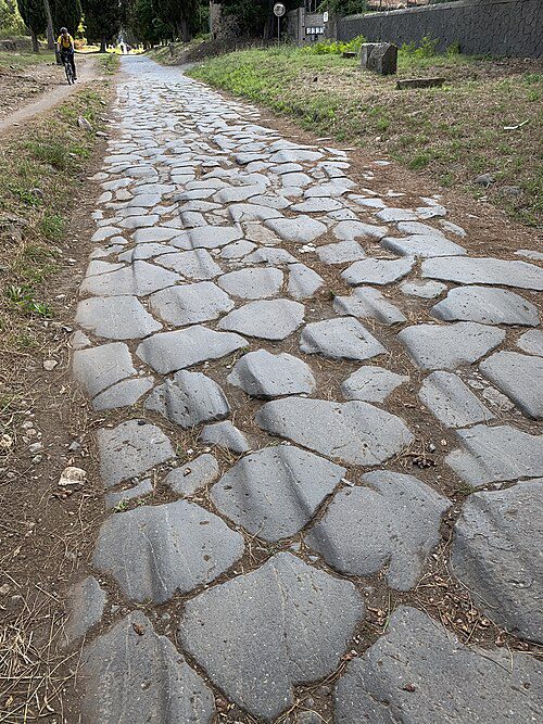
By the height of the empire, Rome had built an extensive, empire-wide network of paved trunk highways, the viae publicae, backed by a far larger mesh of gravel and dirt branch tracks, connecting territory from Hadrian’s Wall to the Euphrates. Roman military surveyors used an instrument called the groma to lay out straight alignments and the chorobates to check gradients, then built roads in layered cross-section: a compacted earth base, the statumen of large stones, the rudus of broken stone and lime mortar, the nucleus of fine concrete, and finally the summum dorsum of fitted polygonal paving stones, cambered to drain rainwater into ditches on either side. Milestones were set every thousand Roman paces, recording distances and the magistrate or emperor responsible for the work. Roman law, as codified by jurists like Ulpian, formally distinguished three tiers: viae publicae maintained at public expense, viae vicinales maintained by local communities, and viae privatae built across private land.
It is a genuine oversimplification to call these purely military roads, and an equally real error to imagine them as open, egalitarian public goods from the start. Roman roads were surveyed and initially built by legions moving toward the frontier, but they functioned immediately as commercial arteries for merchants, drovers, and pilgrims, and Augustus later formalized an imperial postal relay, the cursus publicus, that required official travel warrants to use its horses and waystations. One correction worth making explicitly: the Via Salaria, Rome’s “Salt Road,” is often described as an Etruscan route. It was not. It ran from salt evaporation lagoons at the mouth of the Tiber northeast into the Apennines, and it supplied the Sabines, whose inland territory had no salt of its own; the Etruscans maintained separate salt works of their own north of the Tiber at Veii.
The Persian Royal Road and Imperial Communication
The Achaemenid Empire under Darius I built its communications system around what Herodotus described as a highway running roughly 2,500 kilometers from Sardis in western Anatolia to the administrative capital at Susa, punctuated by 111 royal post stations. A traveler on foot needed about 90 days to cover that distance. An imperial courier riding the relay, the pirradaziš, could do it in seven to nine days. What the Persepolis Fortification Tablets, an Elamite administrative archive dated to roughly 509 to 493 BCE, add to Herodotus’s account is precision about who actually got to use that speed. Official travelers carried a sealed authorization called a halmi, issued by the king or a satrap, which entitled the bearer to rations of flour, wine, and meat and fresh remount horses at the waystations. This has sometimes been simplified into a claim that every traveler needed a permit to use the road at all. The tablets suggest something narrower: ordinary merchants, villagers, and pastoralists could walk the physical route without documentation, but the state’s provisioning, remounts, and military protection were reserved strictly for halmi holders. The road was open; the empire’s support system for using it was not.
Roads Across Political Frontiers
When trade or pilgrimage crossed politically fragmented territory, the mechanism that made it possible was rarely an absence of borders. It was a specific set of institutions built to manage them. Bilateral treaties like the Assyrian mamītum spelled out legal protections and compensation for robbery. Customs duties, called portoria in the Roman world and dātum in Anatolia, were levied at bridges, mountain passes, and city gates, which meant states had a direct fiscal incentive to keep the roads they taxed reasonably safe. Merchant diasporas, including the Sogdians along the Silk Road, the Radhanite traders across the Mediterranean, and the Old Assyrian colonies discussed earlier, established self-governing enclaves in foreign cities that operated under their own legal codes while bridging separate political jurisdictions. Religious and legal safe-conduct frameworks did similar work: the Islamic amān guaranteed safe passage to non-Muslim merchants entering Muslim territory, and the medieval Pax Dei, the Peace of God, formally prohibited European feudal lords from attacking merchants, pilgrims, and clergy. None of these arrangements describes a borderless world. They describe a world with real, enforced boundaries that had developed formal legal technology for crossing them.
Pilgrimage, Culture, and Movement
Pilgrimage routes generated some of the most extensive infrastructure in the pre-modern world, precisely because they were organized around sacred destinations rather than a single ruling capital. The Darb Zubayda ran roughly 1,400 kilometers from Kufa in Iraq across the Arabian Peninsula to Mecca, developed under the Abbasid Caliphate with major financial sponsorship from Queen Zubayda bint Ja’far in the late 8th and early 9th centuries. It featured 54 stations equipped with stone-lined water reservoirs, deep wells, and check-dams, and the Abbasid state paid regular subsidies to Bedouin tribes along its length to keep it secure. In Europe, the Camino de Santiago, developing from the 10th through 12th centuries toward the shrine of St. James in Galicia, crossed the Pyrenean principalities, Navarre, Castile, and León, protected in principle by the Pax Dei and supported by monastic hospices built by orders including Cluny and the Knights Templar. In South Asia, Buddhist pilgrimage networks expanded from the 3rd century BCE under Ashoka, whose rock edicts record the digging of wells and planting of shade trees along routes connecting Lumbini, Bodh Gaya, and Sarnath, corridors that crossed multiple regional kingdoms and were sustained by merchant guilds and monasteries doubling as inns and credit houses.
One widely repeated comparison deserves direct correction here. Australian Aboriginal songlines are sometimes described as one of the world’s oldest road systems. They are not roads in any physical sense. Songlines, known in various Aboriginal languages as Dreaming tracks or Yiri, are oral, mnemonic, and legal frameworks: sung narratives that encode the paths taken by ancestral beings across the landscape, allowing a traveler who knows the song to navigate by memory across enormous distances, identifying water sources and landmarks along the way. People certainly walked routes associated with songlines. But the songline itself lives in memory, ceremony, and law, not in an engineered roadbed, and treating it as a literal road erases what actually makes it remarkable: a continent-scale navigational system that required no physical construction at all.
When Roads Became Instruments of Taxation and Control
Once a route became reliable enough to be useful, it also became reliable enough to tax, and ancient states rarely missed that opportunity. Toll stations, called teloneia or portoria in the Greco-Roman world, were placed at exactly the points where traffic had no alternative: mountain defiles, river fords, and city gates. Roman law formally distinguished the free via publica from earlier, more restricted patterns of movement, but formal public access came bundled with checkpoints, customs inspection, and surveillance of who was traveling and why. States also relied on road infrastructure to move coerced labor into place: Rome’s cura viarum required landowners to maintain the roadbed fronting their own estates, and the Inca mit’a system drafted thousands of workers to cut mountain passes and weave suspension bridges under threat of punishment. Two tiers of mobility typically resulted, a fast, protected relay reserved for state couriers and officials, and a slower, monitored, and taxed form of travel for everyone else. The milestones that line routes like the Via Egnatia, several of them dedicated to specific emperors, are a physical record of exactly this: the state literally inscribing its authority into the surface of the road itself.

How Archaeologists Find Roads From the Air and From Space
A great deal of what is known about ancient road networks was invisible from ground level until recent decades. Declassified imagery from the American CORONA spy satellite program, flown between 1960 and 1972, let archaeologists Tony Wilkinson and Jason Ur map more than 6,000 kilometers of Bronze Age hollow ways across the Syrian Jazira, captured before modern industrial agriculture erased the soil and vegetation marks that revealed them. In Guatemala, the Pacunam LiDAR Initiative used aircraft-mounted laser scanning to penetrate dense jungle canopy across more than 2,100 square kilometers of the Maya Biosphere Reserve, revealing over 60,000 previously unrecorded structures and elevated stone causeways, known as sacbeob, linking major centers including Tikal, El Zotz, and Holmul. In the American Southwest, a combination of thermal imaging, aerial photography, and LiDAR traced the straight, deliberately engineered alignments of the Chaco Canyon road network, including sections of the Great North Road, cut staircases and all, buried under desert sand and scrub for centuries.
What Ancient Roads Reveal About Borders
The framing “civilization before borders” carries a hidden assumption worth naming directly: that territorial boundaries are a modern invention, and that antiquity was somehow borderless. It was not. What differed was the shape of the boundary. Modern borders, formalized after the Peace of Westphalia in 1648 and sharpened by nineteenth-century cartographic surveying, are linear and continuous, placing every square meter of land under one specific sovereign jurisdiction. Ancient frontiers worked differently: they were nodal and zonal, concentrated at administrative centers and thinning outward into marchlands, mountains, and deserts where authority was negotiated rather than absolute. States built fortified frontier systems, such as the Roman limes along the Rhine and Danube or the Sasanian Wall of Gorgan, to monitor movement rather than to seal it completely, and they focused control specifically on transport corridors, placing customs posts at mountain defiles and river crossings instead of trying to patrol an entire desert edge. A road, in this light, was not something that dissolved a border. It was frequently the thing that made a border functional in the first place, since an empire could not garrison a frontier, resupply distant legions, or collect customs revenue without a route to move along.
Roads did not erase the line between one polity and the next. They were, more often than not, how that line was enforced.
None of this is a modern phenomenon born from scratch. There’s a limited but genuine analogy worth drawing to today’s infrastructure. Submarine fiber-optic cables trace soft-sediment ocean plateaus to avoid volcanic ridges, in much the way an ancient road followed the easiest mountain pass. Commercial shipping still funnels through narrow chokepoints, the Straits of Malacca, Hormuz, and Bab el-Mandeb, that function much like the fortified caravan defiles of antiquity. The comparison should not be pushed further than that, however. Modern shipping lanes are protected under the international legal framework of the UN Convention on the Law of the Sea, and civil aviation operates under multilateral treaties through the International Civil Aviation Organization. Pre-modern cross-border transit had no equivalent body of international law; it ran instead on bilateral oaths, tribute payments, hostage exchange, and, when those failed, armed force. The topography that shapes movement has stayed remarkably consistent across five thousand years. The legal architecture built to govern that movement has not.
The Quiet Architecture of Movement
Ancient roads reveal where people moved, what they traded, how they communicated across distance, where they worshipped, and how far a given state’s power actually reached on the ground. They also reveal something less flattering to any romantic reading of the past: how quickly and thoroughly states transformed communal paths of exchange into systems of taxation, military logistics, and territorial administration once the opportunity presented itself. Neither half of that story cancels the other out. Human movement genuinely did carve the earliest spatial framework of civilization, from the Sweet Track to the hollow ways of the Jazira steppe, long before any government existed to claim credit. And states, once they did exist, genuinely did capture, engineer, and fortify those same corridors, turning them into the arteries through which armies marched, tribute flowed, and frontiers were made real rather than theoretical.
What a road actually tells a historian, in the end, is not simply that people once moved between two points. It tells you who was allowed to move quickly and who was not, who paid a toll and who collected it, whose messages traveled by fast relay and whose did not travel at all. That is a more precise form of evidence than the phrase “civilization before borders” suggests, and a more useful one for understanding how deeply movement, trade, and political power have always been tied together.
Ali Mujtuba Zaidi
Ali is an independent history researcher and editor at The Historical Insights, where he writes on ancient infrastructure, engineering, and the systems that shaped early civilizations, drawing on archaeological publications, institutional heritage records, and primary historical sources.
Related reading on The Historical Insights: how early societies shaped civilization and how human civilization began, from farming to cities.
Sources and Further Reading
Earliest Trackways and Pre-State Infrastructure
- John M. Coles and Bryony J. Coles, Sweet Track to Glastonbury: The Somerset Levels in Prehistory (Thames and Hudson, 1986).
- Jennifer Hillam et al., “Dendrochronology of the English Neolithic,” Antiquity 64, no. 243 (1990), DOI:10.1017/S0003598X00077810.
- John Kantner, “Ancient Roads, Modern Mapping: Evaluating Chaco Anasazi Roadways Using GIS Technology,” Penn Museum, Expedition 39, no. 3 (1997).
Trade Networks, Assyrian Kültepe, and Indus–Mesopotamia
- Mogens Trolle Larsen, Ancient Kanesh: A Merchant Colony in Bronze Age Anatolia (Cambridge University Press, 2015).
- Gojko Barjamovic, A Historical Geography of Anatolia in the Old Assyrian Colony Period (Museum Tusculanum Press, 2011).
- Gregory L. Possehl, The Indus Civilization: A Contemporary Perspective (AltaMira Press, 2002).
- Daniel T. Potts, The Arabian Gulf in Antiquity, vol. 1 (Clarendon Press, 1990).
Andean and Inca Road Systems
- John Hyslop, The Inka Road System (Academic Press, 1984).
- Terence N. D’Altroy, The Incas (Blackwell, 2002).
- UNESCO World Heritage Centre, “Qhapaq Ñan, Andean Road System,” World Heritage List #1459 (2014).
Mesopotamian, Roman, and Persian Roads
- Elizabeth C. Stone, “The Mesopotamian Urban Experience,” in Settlement and Society: Essays Dedicated to Robert McCormick Adams (Cotsen Institute of Archaeology, UCLA, 2007).
- Ray Laurence, The Roads of Roman Italy: Mobility and Cultural Change (Routledge, 1999).
- Lorenzo Quilici, “Land Transport, Part 1: Roads and Bridges,” in The Oxford Handbook of Engineering and Technology in the Classical World, ed. John Peter Oleson (Oxford University Press, 2008).
- Pierre Briant, From Cyrus to Alexander: A History of the Persian Empire, trans. Peter T. Daniels (Eisenbrauns, 2002).
- Wouter F. M. Henkelman, “Hazañna: On the Road with the Great King,” in Limits of Universal Rule (Harrassowitz Verlag, 2017).
Frontiers, Pilgrimage, and Remote-Sensing Archaeology
- Adam T. Silverstein, Postal Systems in the Pre-Modern Islamic World (Cambridge University Press, 2007).
- Sa’ad A. Al-Rashid, Darb Zubayda: The Pilgrim Road from Kufa to Mecca (Saudi Commission for Tourism and National Heritage, 2010).
- Jason A. Ur, “CORONA Satellite Photography and Ancient Road Networks: A Northern Mesopotamian Case Study,” Antiquity 77, no. 295 (2003), DOI:10.1017/S0003598X00061398.
- Marcello A. Canuto et al., “Ancient Lowland Maya Complexity as Revealed by Airborne Laser Scanning of Northern Guatemala,” Science 361, no. 6409 (2018), DOI:10.1126/science.aau0137.
Frequently Asked Questions
What are the oldest roads in history?
The oldest surviving engineered routes include the Sweet Track in Somerset, England, dated by tree-ring analysis to the winter of 3807/3806 BCE, and the Widan el-Faras quarry road in Egypt, built during the Old Kingdom’s 4th and 5th Dynasties, roughly 2600 to 2200 BCE. Informal footpaths and animal trails are older still, but they were never engineered structures.
Did roads exist before empires?
Informal paths, hollow ways, and communal timber causeways like the Sweet Track predate centralized states by thousands of years. What generally required state-level organization was not the path itself, but continuous, engineered, graded, and bridged long-distance networks, which appear consistently alongside early states and empires.
What was the Sweet Track?
A two-kilometer elevated timber walkway across a reed swamp in the Somerset Levels, connecting the sand island of Westhay to the Polden Hills. It was built in a single season around 3807/3806 BCE by a Neolithic farming community with no centralized government, and abandoned about a decade later as water levels rose.
How did ancient trade routes work?
Long-distance trade rarely moved freely across open borders. It operated through chartered merchant settlements, bilateral treaties, transit tolls, armed caravan escorts, and formal safe-conduct agreements. The Old Assyrian network between Aššur and Kültepe is among the best-documented examples, organized through legally chartered colonies rather than informal roadside stops.
What was the Inca Qhapaq Ñan?
The Andean road system, extending an estimated 30,000 to 40,000 kilometers. The Inca did not build it from nothing; they integrated, paved, and standardized earlier regional networks built by the Wari, Tiwanaku, and Chimú, then restricted most of the finished system to state, military, and administrative use.
Were Roman roads only military roads?
No. Roman viae publicae were surveyed and initially built by the military for rapid troop movement, but they functioned immediately as multi-purpose infrastructure carrying merchants, pilgrims, and civilian travelers, alongside the state’s own postal relay, the cursus publicus.
What was the Persian Royal Road?
An administrative highway system under the Achaemenid Empire, with a documented stretch of roughly 2,500 kilometers from Sardis to Susa and 111 waystations. Couriers carrying sealed travel authorizations, called halmi, could cross it in seven to nine days by relay horse, versus about 90 days on foot.
How did ancient roads cross political frontiers?
Through bilateral commercial treaties, customs tolls collected at fixed checkpoints, self-governing merchant enclaves, and legal safe-conduct protections such as the Islamic amān or the medieval Pax Dei. These institutions, not an absence of borders, made long-distance travel across divided territory possible.
How did roads help governments control territory?
Roads let states move armies quickly, station customs officials at mountain passes and river crossings, and extend administrative reach into hinterlands that would otherwise be difficult to govern or tax. Checkpoints and travel permits turned transit corridors into tools of surveillance and revenue collection.
How do archaeologists find ancient roads?
Declassified CORONA spy satellite imagery and airborne LiDAR have revealed thousands of kilometers of routes invisible from the ground, including Bronze Age hollow ways in northern Syria and stone causeways beneath the forest canopy of the Maya lowlands in Guatemala.